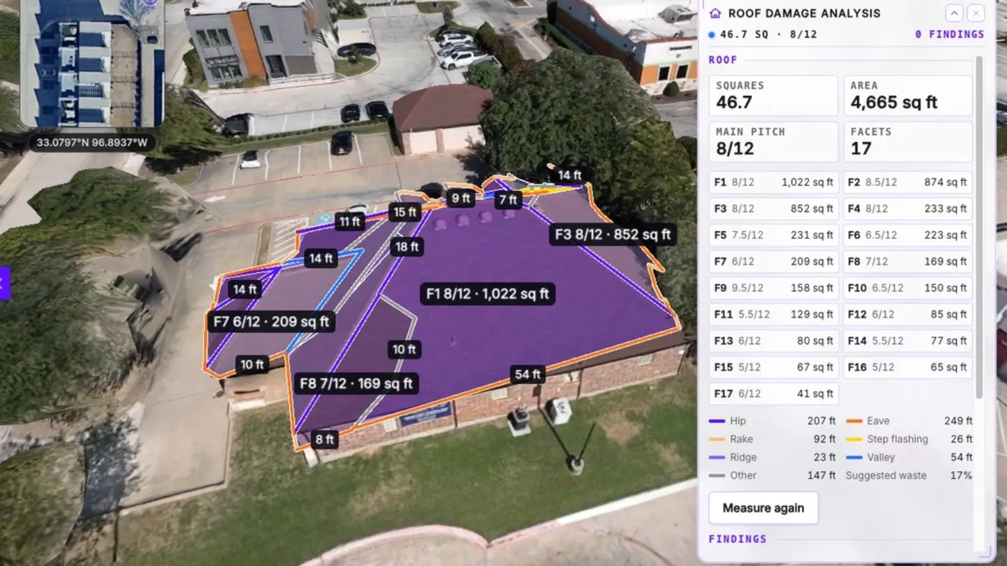
SkyeBrowse released a roof inspection tool on Thursday, November 5, that measures a roof and screens it for storm damage from one drone flight. On the finished 3D model, Roof Damage Analysis finds the roof, outlines every facet and reports squares, area, main pitch and the ridge, hip, valley, eave and rake lengths. An AI scan then pins hail hits and wind creases on the model, and the inspector approves or rejects each one before anything reaches the PDF report.
It runs on SkyeBrowse Pro, at $49.99 per model or $39.99 on annual billing, and on the Public Safety & Enterprise plan. The same release adds a 2D map export built for SARTopo and ArcGIS, a contour DXF, and survey correction with ground control points.
The Weather tab also pre-fills a date of loss from the nearest NOAA hail report. NOAA labels every report on that list preliminary.
The AI Scan Reads Up to 24 Images in 20 Seconds, and the Inspector Signs Off on Every Pin #
“Run AI damage scan” reviews up to 16 flight frames and 8 gallery photos in about 20 seconds and marks each finding Likely or Possible. It looks for hail hits, wind creases, lifted shingles, granule loss, cracked tiles, ponding, membrane tears and tarps, and only approved findings reach the report.
SkyeBrowse calls the scan a screening aid and says it does not determine cause, coverage or repair scope. The company has put AI on the processing side before, with the January quality check that reprocesses a crash-scene model when the first pass falls short, and this one sits in front of the inspector instead. The measurements are the inspector’s to correct too: corners drag, corners can be added, and facets can be added or deleted before the numbers are final.
On the commercial building in the cover image, the tool found 17 facets over 4,665 square feet (433 square meters), 46.7 squares at an 8/12 main pitch, with 249 feet (76 meters) of eave and a suggested waste of 17%. SkyeBrowse overhauled its pricing in September, and it aims this tool at roofing contractors and insurance adjusters, two trades outside the public safety agencies that fill its customer list and the crash-scene work DroneXL has covered since August 2021.
The Date of Loss Comes From a NOAA List That NOAA Calls Preliminary #
The Weather tab lists Storm Prediction Center hail, wind and tornado reports within 25 miles (40 kilometers) of the model over the year before the flight. It sets the date of loss from the nearest hail report. The SPC says that list “likely does not contain all severe weather reports.”
The SPC compiles the list from the local storm reports National Weather Service offices send out. In SkyeBrowse’s demo, clicking a June 2, 2026 hail report near the house sets the date of loss. The Report tab then builds a Roof Damage Report PDF with a cover summary, per-facet measurements, a top-down roof diagram, a damage summary with test squares, photo evidence, the storm history, the methodology and a reviewer sign-off.
The 2D Map Now Builds Itself for SARTopo or AutoCAD, and GCPs Move the Model #
Download on the 2D map of any georeferenced model now asks where the map is going and builds the matching file in the browser, for SARTopo and CalTopo, ArcGIS Pro and Online, Google Earth, AutoCAD and Civil 3D, or Global Mapper. SkyeBrowse remembers the choice for the next model.
Topographic Map exports a Contours DXF next to the DTM GeoTIFF and ground LAS, with every elevation label matching its line. With Bare earth on, the contours follow the ground under vehicles and trees. Heights run from the scan’s lowest ground rather than a survey datum, so a crew ties them to its own datum before design work.
The GCPs tool used to report how far a model sat from surveyed points. Now each point can be set to Control or Check, and Apply correction fits a vertical offset, a 3D shift or a seven-parameter correction. The point cloud, mesh, measurements, annotations and every LAZ, GeoTIFF, GLB, OBJ, USDZ and CAD download move together, and check points stay out of the fit so the accuracy report stays independent. GCPs and the topographic exports are included in the $5 first Commercial model SkyeBrowse offers new organizations. Smaller additions: two-finger panning on phones, HEIC and Insta360 .insp uploads, processing time on each model’s General tab, and the original flight log as a download.
DroneXL’s Take #
I’d buy this for the measurements before the damage scan. EagleView, the incumbent in aerial roof reports, lists its Premium Roof Report from $24.25, and that report is measured on EagleView’s own aircraft imagery, flown on EagleView’s schedule rather than yours. SkyeBrowse charges twice that per model and makes you fly the roof yourself, and in return the squares and the pitch come off the roof as it is the morning after the hail. For a crew with twenty roofs and one ladder that trade is easy, because the flight is the part they would do anyway. I’d treat the AI pins as a to-do list for the ladder rather than as evidence, and SkyeBrowse itself calls them a screening aid. I’d still check the date of loss by hand, because NOAA calls its own list preliminary.
Sources: SkyeBrowse newsletter and press release, SkyeBrowse pricing, NOAA Storm Prediction Center, EagleView. DroneXL uses automated tools to support research and source retrieval. All reporting and editorial perspectives are by Haye Kesteloo. Read our editorial standards.